Hurricane Tips for the Weather-Wise Mariner
Recent Posts


| By Capt Lisa Batchelor Frailey
Hurricane season is upon us, and it portends to be an active one. With so many sources of information available, it’s easy to get overloaded by the variety of data and media hype. Here are some definitions and tips to weed out the key information and keep you prepared. Definitions – adapted from National Hurricane Center’s Glossary: Tropical cyclone – a rotating, organized system of clouds and thunderstorms that originates over tropical or subtropical waters and has a closed low-level circulation. TC’s rotate counterclockwise in the Northern Hemisphere. They are further classified as:
Storm Surge – An abnormal rise in sea level accompanying a hurricane or other intense storm. (Storm surge is generally the most dangerous aspect of a storm for mariners in port, causing the greatest damage to life and property) National Hurricane Center (NHC) is the primary source of hurricane forecasts for the US. The information is distributed in various formats – text, graphic, voice – to reach all users. Commercial organizations use the same base layer of information, but use value-added graphics and discussions. The combination can be confusing, so look carefully! 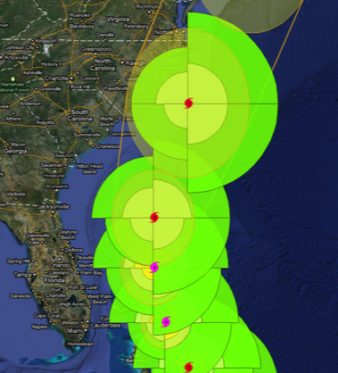 Weather Underground Graphic of Hurricane Irene, Aug 2011 Size Matters – a hurricane’s size is important because of the area it impacts, but its strength (intensity of wind speed) and track are even more important. Things to look for in the graphics:
Understanding these factors of a hurricane forecast will help you keep a sharp weather eye, so you can prepare appropriately. |


No comments
Be the first one to leave a comment.